


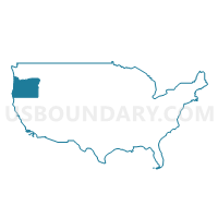
Lane County (Outside Eugene & Springfield Cities) PUMA, Oregon
About
Outline
+PUMA%2c+Oregon_A280.png)
Summary
| Unique Area Identifier | 193820 |
| Name | Lane County (Outside Eugene & Springfield Cities) PUMA |
| State | Oregon |
| Area (square miles) | 4,621.28 |
| Land Area (square miles) | 4,453.74 |
| Water Area (square miles) | 167.54 |
| % of Land Area | 96.37 |
| % of Water Area | 3.63 |
| Latitude of the Internal Point | 43.92827630 |
| Longtitude of the Internal Point | -122.89767790 |
Maps
+PUMA in Oregon.png)
Graphs
Select a template below for downloading or customizing gragh for Lane County (Outside Eugene & Springfield Cities) PUMA, Oregon
+PUMA%2c+Oregon_T0.png)
+PUMA%2c+Oregon_T1.png)
+PUMA%2c+Oregon_T2.png)
+PUMA%2c+Oregon_T3.png)
+PUMA%2c+Oregon_T4.png)
+PUMA%2c+Oregon_T5.png)
+PUMA%2c+Oregon_T6.png)
+PUMA%2c+Oregon_T7.png)
+PUMA%2c+Oregon.png)
Neighbors
Neighoring Public Use Microdata Area (by Name) Neighboring Public Use Microdata Area on the Map
- Columbia, Lincoln, Clatsop & Tillamook Counties PUMA, OR
- Deschutes County PUMA, OR
- Douglas County PUMA, OR
- Klamath, Malheur, Lake & Harney Counties PUMA, OR
- Lane County (East Central)--Eugene (Northeast) & Springfield Cities PUMA, OR
- Lane County (West Central)--Eugene City (West & South) PUMA, OR
- Linn & Benton Counties PUMA, OR
Top 10 Neighboring County (by Population) Neighboring County on the Map
- Lane County, OR (351,715)
- Deschutes County, OR (157,733)
- Linn County, OR (116,672)
- Douglas County, OR (107,667)
- Benton County, OR (85,579)
- Klamath County, OR (66,380)
- Lincoln County, OR (46,034)
Top 10 Neighboring County Subdivision (by Population) Neighboring County Subdivision on the Map
- Eugene-Springfield CCD, Lane County, OR (252,962)
- Sisters-Millican CCD, Deschutes County, OR (27,974)
- Cottage Grove CCD, Lane County, OR (18,855)
- Sutherlin CCD, Douglas County, OR (15,877)
- Badger Mountain CCD, Lane County, OR (12,852)
- Florence CCD, Lane County, OR (12,333)
- Junction City CCD, Lane County, OR (11,809)
- Creswell CCD, Lane County, OR (9,388)
- Waldport CCD, Lincoln County, OR (7,953)
- Harrisburg CCD, Linn County, OR (6,694)
Top 10 Neighboring Place (by Population) Neighboring Place on the Map
- Eugene city, OR (156,185)
- Springfield city, OR (59,403)
- Cottage Grove city, OR (9,686)
- Florence city, OR (8,466)
- Junction City city, OR (5,392)
- Creswell city, OR (5,031)
- Veneta city, OR (4,561)
- Harrisburg city, OR (3,567)
- Oakridge city, OR (3,205)
- Dunes City city, OR (1,303)
Top 10 Neighboring Unified School District (by Population) Neighboring Unified School District on the Map
- Eugene School District 4J, OR (150,188)
- Bend-La Pine Administrative School District 1, OR (107,386)
- Springfield School District 19, OR (73,859)
- Lincoln County School District, OR (46,192)
- Redmond School District 2J, OR (45,507)
- Klamath County School District, OR (42,784)
- Bethel School District 52, OR (37,957)
- South Lane School District 45J, OR (18,770)
- Siuslaw School District 97J, OR (14,672)
- Sweet Home School District 55, OR (14,649)
Top 10 Neighboring State Legislative District Lower Chamber (by Population) Neighboring State Legislative District Lower Chamber on the Map
- State House District 53, OR (73,781)
- State House District 55, OR (66,629)
- State House District 14, OR (64,049)
- State House District 8, OR (62,550)
- State House District 23, OR (62,427)
- State House District 12, OR (62,080)
- State House District 17, OR (61,383)
- State House District 11, OR (60,899)
- State House District 7, OR (59,574)
- State House District 10, OR (58,977)
Top 10 Neighboring State Legislative District Upper Chamber (by Population) Neighboring State Legislative District Upper Chamber on the Map
- State Senate District 27, OR (155,590)
- State Senate District 12, OR (128,429)
- State Senate District 7, OR (126,608)
- State Senate District 28, OR (125,860)
- State Senate District 9, OR (123,674)
- State Senate District 6, OR (122,979)
- State Senate District 4, OR (122,124)
- State Senate District 5, OR (117,755)
Top 10 Neighboring 111th Congressional District (by Population) Neighboring 111th Congressional District on the Map
- Congressional District 2, OR (769,987)
- Congressional District 5, OR (757,128)
- Congressional District 4, OR (739,234)
Top 10 Neighboring Census Tract (by Population) Neighboring Census Tract on the Map
- Census Tract 25.03, Lane County, OR (7,689)
- Census Tract 43, Lane County, OR (6,717)
- Census Tract 306, Linn County, OR (6,694)
- Census Tract 44.01, Lane County, OR (5,967)
- Census Tract 5, Deschutes County, OR (5,921)
- Census Tract 22.02, Lane County, OR (5,741)
- Census Tract 11.01, Lane County, OR (5,549)
- Census Tract 17, Lane County, OR (5,338)
- Census Tract 9.03, Lane County, OR (5,319)
- Census Tract 18.01, Lane County, OR (5,309)
Top 10 Neighboring 5-Digit ZIP Code Tabulation Area (by Population) Neighboring 5-Digit ZIP Code Tabulation Area on the Map
- 97701, OR (58,993)
- 97402, OR (50,342)
- 97405, OR (44,645)
- 97478, OR (37,011)
- 97477, OR (36,874)
- 97404, OR (32,255)
- 97424, OR (17,594)
- 97439, OR (14,343)
- 97386, OR (13,567)
- 97448, OR (12,244)